
Fortell venner om denne varen:
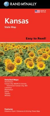
Rand McNally Easy to Read Folded Map: Kansas State Map
Rand Mcnally

Rand McNally Easy to Read Folded Map: Kansas State Map
Rand Mcnally
Rand McNally's Easy To Read State Folded Map is a must-have for anyone traveling in and around Kansas, offering unbeatable accuracy and reliability at a great price. Our trusted cartography shows all Interstate, U. S., state, and county highways, along with clearly indicated parks, points of interest, airports, county boundaries, and streets. The easy-to-use legend and detailed index make for quick and easy location of destinations. You'll see why Rand McNally folded maps have been the trusted standard for years. - Regularly updated, full-color maps. - 50% larger map with a bigger type size than the Rand McNally Folded Map. - Clearly labeled Interstate, U. S., state, and county highways. - Indications of parks, points of interest, airports, county boundaries, and more. - Mileage and driving times map. - Detailed index. - Convenient folded size. Coverage Area Detailed maps of: Hutchinson, Kansas City, MO/KS & Vicinity, Downtown Kansas City, MO; Lawrence, Manhattan, Salina, Topeka, Wichita. Product Details: Dimensions (unfolded): 28 x 40.
| Media | Bøker Pocketbok (Bok med mykt omslag og limt rygg) |
| Utgitt | 14. april 2022 |
| ISBN13 | 9780528025808 |
| Utgivere | RAND MCNALLY |
| Mål | 250 g (Estimert vekt) |
| Språk | Engelsk |
Mer med Rand Mcnally


![Cover for Rand McNally · A Pocket Atlas of the [world] [cartographic Material]: Presented to the Patrons and Friends of the Chicago & North-Western Ry. Co. With the Compliments of the Passenger Department (Pocketbok) (2021)](https://imusic.b-cdn.net/images/item/original/417/9781015179417.jpg?rand-mcnally-2021-a-pocket-atlas-of-the-world-cartographic-material-presented-to-the-patrons-and-friends-of-the-chicago-north-western-ry-co-with-the-compliments-of-the-passenger-department-pocketbok&class=scaled&v=1649334010)


Andre har også kjøpt
![Cover for Preben Hansen · Turen Går Til: Turen går til Californien & Vestlige USA (Heftet bok) [5. utgave] (2021)](https://imusic.b-cdn.net/images/item/original/578/9788740063578.jpg?preben-hansen-2021-turen-gaar-til-turen-gaar-til-californien-vestlige-usa-heftet-bok&class=scaled&v=1623395637)
![Cover for Glenn Bech · Jeg anerkender ikke længere jeres autoritet (Heftet bok) [1. utgave] (2022)](https://imusic.b-cdn.net/images/item/original/068/9788702382068.jpg?glenn-bech-2022-jeg-anerkender-ikke-laengere-jeres-autoritet-heftet-bok&class=scaled&v=1661552279)
![Cover for Anne Hjernøe · Spis dig stærk, let og mæt (Innbunden bok) [1. utgave] (2021)](https://imusic.b-cdn.net/images/item/original/978/9788740065978.jpg?anne-hjernoee-2021-spis-dig-staerk-let-og-maet-innbunden-bok&class=scaled&v=1612008725)
![Cover for Johan Olsen · Læs selv-serie: Hvad er en prut? Hvad er en bussemand? - Læs selv-serie (Innbunden bok) [1. utgave] (2022)](https://imusic.b-cdn.net/images/item/original/941/9788740070941.jpg?johan-olsen-2022-laes-selv-serie-hvad-er-en-prut-hvad-er-en-bussemand-laes-selv-serie-innbunden-bok&class=scaled&v=1643963541)


Se alt med Rand Mcnally ( f.eks. Pocketbok , Landkart , Innbunden bok , Bok og Spiralbok )